
Off-ground harvest is continuing to advance as a viable method for harvesting almonds in California, and a new UC Davis research project is using precision agriculture technologies to further capitalize on its benefits.
The project, which includes researchers with UC Davis and USDA-ARS, and in partnership with Erick Nielsen Enterprises, Inc., was envisioned by UC Davis Plant Sciences Professor Patrick Brown. It uses the off-ground harvester as a “method” to measure individual trees’ yields across an orchard, according to UC Davis Professional Researcher and project collaborator Sat Darshan S. Khalsa. The purpose of measuring individual trees instead of taking an average of an orchard block, Khalsa said, is to highlight variabilities in their orchards.
Making growers aware of variabilities will assist them in making more precise management decisions throughout their orchards.
“If growers are still only looking at the average yields across blocks and managing those blocks as average units, it’s really hard to start talking about more precision agriculture,” Khalsa said.
Precision Yield Monitoring
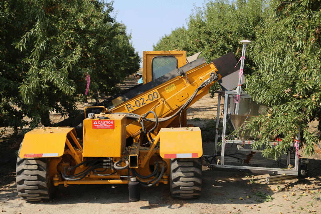
A UC Davis team led by Stavros G. Vougioukas, professor in the Department of Biological and Agricultural Engineering, designed a weighing bin to precisely measure the yield coming off of each tree. As nuts are shaken from trees and collected in the harvester, they move along a conveyor belt and are captured in the weighing bin. The bin then communicates to the driver when to drop the nuts in the windrow.
The weighing bin itself, engineered by Development Engineer Dennis Sadowski, attaches to the side of the Erick Nielson Enterprises off-ground harvester. Post-doctoral Researcher Chen Peng designed the yield monitoring software as well as a GPS software that maps the yield of individual trees in the orchard. The GPS mapping allows growers to see how much specific trees in an orchard block are producing, which can be helpful for diagnosing water and/or nutrition issues more accurately within blocks.
“What we wanted to know is, ‘What is the wide range of variability of trees in the orchard and how are those trees differing in yield, but what are the drivers of those differences?’” said Khalsa. “So what we did is we used satellite imagery to show the vegetative index of the existing orchards we were working in, and then randomly selected trees of all ranges of productivity and identified them as our data trees. Within those data trees, we’re then starting to take more intensive measurements around carbohydrate status, water status and nutrient status as well as counts on flowers and fruit set to understand what those yield drivers are.”
The weighing bin is still in the first version of development, and the research collaborators have plans for improvement. Khalsa said the project is primarily focused on improving the efficiency of the weighing steps so that weight can be taken in real time instead of after all the nuts have passed through the bin.
“That will allow the shaking to double in speed, and right now, we’re not quite there,” he said.
Additionally, the current iteration of the weighing bin requires additional labor during harvest due to how the bin piles up nuts in windrows, but Khalsa said this is only temporary.
“It hasn’t quite been designed in such a way with commercial machinery to optimize all operations of the harvest,” he said. “Certainly, what we want to see in the future is the ability to weigh the nuts and have some sort of broadcasting of those nuts gently onto the field so that they’re not building up in piles. So what our team was doing as a courtesy to the grower is we were following behind the harvester and raking those nuts out so that they dry effectively, but that’s not a practice we would ever propose for this type of work.”
Khalsa said the project is looking for additional industry collaborators to help design different types of weighing bins for different types of harvesters, keeping in mind the goal of the operation which is to get the nuts in a windrow where they can dry and be picked up effectively. This process eliminates sweeping and marries with one of the Almond Board’s 2025 harvest goals of reducing harvest dust levels.
Remote Sensing and Satellite Imagery
Another important goal of the project is yield prediction, which requires the ground-truthing data from the precision off-ground harvester for algorithm training and validation purpose. While the research project involves measuring yield indicators of individual trees to predict yield earlier in the season, this method is not feasible for the grower. Khalsa said that the project is using AI/machine learning technology paired with aerial imagery to get a bigger picture and make things easier.
The remote sensing technology will assist with predicting yield earlier in the season so that growers can know how to adaptively manage their water and nutrients, Khalsa said. Additionally, ground-based sensor networks, much like those already being used by growers to measure soil water and tree water status, are being used in tandem with aerial remote sensing and tractor mounted imaging to further enhance the management scope. These ground-based sensor networks and tractor mounted imaging are currently being researched by UC Davis professors Isaya Kisekka and Mason Earles. Yufang Jin, professor in the Department of Air, Land and Water Resources at UC Davis, is heading the aerial remote sensing and yield prediction aspects of the project.
Jin said that the remote sensing looks at bloom dynamics early in the season, including flower intensity and bloom timing overlap between rows, along with other phenological and physiological traits like canopy biomass and water stress. “We can monitor from space when the flowers start to come out and then track day-to-day dynamics as well as quantify intensity of peak bloom,” she said. “We can ingest all of that information into a final yield prediction statistical model.”
Using this model, the researchers will be able to relate the yields in the weighing bin during off-ground harvesting to yield drivers within the orchard, with the hope of influencing growers to make more tailored management decisions.
Water Management
The project is also looking at water management data on trees in blocks as it pertains to stress levels. Similar to the yield prediction data, these data are compared with the precise yield measurements from the off-ground harvester to determine a more homogenized management pattern for the orchard. Also similar to the yield prediction data, the water management data is captured through remote sensing tools.
Andrew McElrone, a research plant physiologist with USDA-ARS and adjunct faculty at UC Davis, said that water use is measured on the ground with lots of sensors, including a flux tower, which is used to ground truth remotely sensed measurements of water use. The remote sensing tools can be used to map the heterogeneity of a block, according to McElrone.
“That’s ultimately what the growers are looking for,” he said. “They see parts of their plots that are getting much higher yields than others and they want everything to reach whatever the maximum potential is in that area. They’re trying to maximize uniformity because it helps improve harvest time as well.”
Additionally, remote sensing makes it easier in general to survey the orchard.
“What the remote sensing can do is allow you to cover a lot more acreage more rapidly without having to send armies of people into the field to do intensive measurements,” he said, noting that the cost is coming down for these tools as well.
Remote sensing tools for estimating evapotranspiration will soon be more widely available through OpenET, a web application powered by Google Earth Engine that uses cutting edge models and publicly available satellite and weather station data to estimate field-level water consumption at potentially daily, monthly and yearly intervals.


